Emergency responders, school children, planners and even tourists half way around the globe one day will be able to explore Orlando in 3-D with the click of a mouse.
University of Central Florida architecture students, city planners and other agencies have partnered to create the Orlando Virtual City, an interactive project using technology to help prepare for the future while preserving history for generations to come.
Electronic 3-D representations of downtown buildings will be combined with historical photographs, written and oral histories, cultural information and infrastructure images to create a rich repository of information.
“This project represents a unique experiment in integrating the preservation and display of cultural heritage with urban planning and facilities management,” said Thomas McPeek, assistant professor of architecture at UCF’s School of Visual Arts & Design. “It will provide the public with a means of experiencing the life of the city across time – ‘looking over the shoulders’ of the city’s planners and managers.”
Both the city and UCF started working on independent projects to achieve similar architectural goals before they discovered that their paths crossed about a year ago. They then teamed up to develop the city’s virtual world through 3-D technology.
The project gained international exposure this week when several of McPeek’s undergraduate research students presented their progress at a conference in Orlando before about 300 professionals from around the world that create and work with three-dimensional data.
Yuly Mojocoa, Diana Ariza, Trevor Stephens, Terrance Perdue, Massey Brooks, Natalia Savorotca and Lucas Najle discussed the team’s work during the FARO 3-D Documentation Conference. FARO develops products that create 3D representations.
“We would like to have a virtual representation of the city to be used for planning purposes for everything across the board: infrastructure, street drainage, fire rescue, police training,” said Holly Stenger, a city project manager and architect. “It’s a planning tool.” The images also could be used to refurbish buildings if they are damaged by a hurricane, fire or some other disaster.
“First responders would have access and would benefit,” Stenger said. “Part of what we envision is to locate an incident and see what and where it is, and how to respond.”
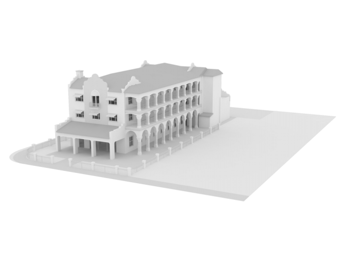
The exteriors of about 75 downtown buildings so far have been modeled to create virtual 3-D images, and some have been supplemented with interior images made by laser scanners. Examples of the early models include the 29,000-square-foot Orlando Public Library, the Sligh Boulevard train station, and Howard Middle School, which at one time served as Orlando High School. The images will be able to be viewed from all angles on a computer screen.
This semester, the project turned its focus on the Church Street tourist and commercial area, and its nearby Interstate 4 overpass; next on the agenda is the landscape along Orange Avenue.
“Before I came here I had some preconceived notions of what Orlando was, and most of them were about Disney and theme parks,” McPeek said. “I didn’t realize what a wonderfully historical and cultural city it is.”
Najle, a UCF junior working on the project and a graduate of Winter Park High School, said metropolitan Orlando has changed dramatically just since he was a young boy, and that this project “is a really great way to preserve the way Orlando is now. This is a new take on how you can go about preserving historical buildings.”
Stenger said Orlando’s urban-design objectives call for 3-D modeling, and the city is among the pioneering few to tackle the concept.
“Los Angeles and Disney and Universal have similar models for their use,” she said. “We are kind of a hub with the digital and gaming industry, and we have the talent and information to pull it all together.”
Najle said it is exciting to be on the front edge of the new applications.
“A couple cities in Europe have virtual cities and we’re bringing that technology here,” he said.
Najle said that working on the project has already helped give him some insights that will benefit him as a professional architect.
“This really connects me to the building process,” he said.
The project is still in its data-acquisition stage and no specific date has been set to post all the collected images and cultural information online.
In addition to the City of Orlando, the project’s partners also include FARO, the Orlando chapter of the American Institute of Architects, and the UCF Synthetic Reality Lab.
“This is something that we will continue to add to,” McPeek said. “It will be an ongoing repository.”